Lacawac Hiking Trails
  • Home
  • About
    • Sources
    • Contact Us
  • Visitors Center
    • Native Plant Garden
    • Bees
    • Weather Station
  • Historic Great Camp Trail
    • Connell Park
    • Sustainable Forestry
    • Hemlock Woolly Adelgid
    • Early Years
    • Field Station
  • Lake Lacawac Trail
    • White Pine
    • Eastern Hemlock
    • Sphagnum Moss
    • Blueberry Bushes
    • Bog Plants
    • Lake Lacawac
    • Glacial Bog
    • Pickerelweed
    • Diversity of Birds
    • Glacial Erratic Rock
    • American Black Bear >
      • Diet
      • Population
      • Reproduction
  • Big Lake Trail
    • Food Web
    • North American Beaver
    • Osprey
    • Watershed
    • Japanese Barberry >
      • Characteristics
      • Threat to Forest
      • Control Methods
    • Minerals & Rocks >
      • Minerals
      • Igneous Rocks
      • Sedimentary Rocks
      • Metamorphic Rocks
      • Identification
    • Sugar Maple
    • Streams
    • Hydroelectric Dam
    • Lake Wallenpaupack >
      • Electricity Generation
      • Recreation
      • Watershed Management
    • Wild Grapevines
    • Hayscented Fern
  • Maurice Broun Trail
    • Fields & Meadows
    • Stone Walls
    • Gypsy Moth Caterpillars
    • Oak Trees >
      • White Oak
      • Red Oak
      • Black Oak
    • Raccoons
    • Owls
    • Snakes >
      • Snake ID
    • Bats >
      • Bat Houses
  • Ledges Trail
    • Deer Exclosures
    • Geological Faults >
      • Normal Fault
      • Reverse Fault
      • Strike-slip Fault
    • Wild Orchids
    • Ledges
    • Ferns
    • Mosses & Lichen
    • Vernal Pools
    • Mushrooms
  • Warbler Trail
  • Partner Ridge Trail
  • Watres Trail
    • Edge Effect
    • Hummocks and Hollows
  • Carriage-Lakefront Trails
    • Native Fish
    • Lake Research
    • Aquatic Vegatation
    • Plankton
    • Lake Succession >
      • Oligotrophic Lake
      • Mesotrophic Lake
      • Eutrophic Lake

Lake Lacawac

 “The Southernmost unpolluted glacial lake in North America” 

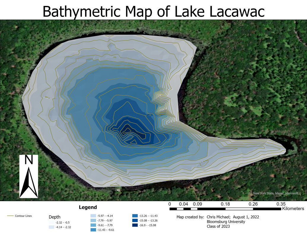
Lake Lacawac was formed about 13,000 years ago, at the end of the last ice age, when the Wisconsinan glacier carved a crater in the red Catskill sandstone and as the climate warmed, melting ice created a scour lake. It is currently 52 acres in size, about a third smaller than its original size.

At its deepest point it is now 43 feet in depth; almost half its original depth. The lake is eutrophic due to the accumulating layers of organic dead plant material and sediment deposited over the years.

The lake is shaped like a half moon and has two distinct habitats. The prevailing wind pattern from the northwest causes continuous wave action that breaks down sandstone and washes away plant material from the eastern and southern shores leaving them sandy and barren. The north and west shores are a bog area caused by years of fallen trees and deteriorating plant matter. 


Click the link below to learn more about Lake Lacawac!


Lake Research

Location

About lacawac sanctuary

Lacawac Sanctuary Field Station and Environmental Education Center is an independent, non-profit, environmental education organization located on the shore of Lake Wallenp​aupack in the Northern Poconos.  We operate solely on program fees, memberships, sponsorships, grants and private donations from people like you

Contact Us

    Subscribe Today!

Submit
  • Home
  • About
    • Sources
    • Contact Us
  • Visitors Center
    • Native Plant Garden
    • Bees
    • Weather Station
  • Historic Great Camp Trail
    • Connell Park
    • Sustainable Forestry
    • Hemlock Woolly Adelgid
    • Early Years
    • Field Station
  • Lake Lacawac Trail
    • White Pine
    • Eastern Hemlock
    • Sphagnum Moss
    • Blueberry Bushes
    • Bog Plants
    • Lake Lacawac
    • Glacial Bog
    • Pickerelweed
    • Diversity of Birds
    • Glacial Erratic Rock
    • American Black Bear >
      • Diet
      • Population
      • Reproduction
  • Big Lake Trail
    • Food Web
    • North American Beaver
    • Osprey
    • Watershed
    • Japanese Barberry >
      • Characteristics
      • Threat to Forest
      • Control Methods
    • Minerals & Rocks >
      • Minerals
      • Igneous Rocks
      • Sedimentary Rocks
      • Metamorphic Rocks
      • Identification
    • Sugar Maple
    • Streams
    • Hydroelectric Dam
    • Lake Wallenpaupack >
      • Electricity Generation
      • Recreation
      • Watershed Management
    • Wild Grapevines
    • Hayscented Fern
  • Maurice Broun Trail
    • Fields & Meadows
    • Stone Walls
    • Gypsy Moth Caterpillars
    • Oak Trees >
      • White Oak
      • Red Oak
      • Black Oak
    • Raccoons
    • Owls
    • Snakes >
      • Snake ID
    • Bats >
      • Bat Houses
  • Ledges Trail
    • Deer Exclosures
    • Geological Faults >
      • Normal Fault
      • Reverse Fault
      • Strike-slip Fault
    • Wild Orchids
    • Ledges
    • Ferns
    • Mosses & Lichen
    • Vernal Pools
    • Mushrooms
  • Warbler Trail
  • Partner Ridge Trail
  • Watres Trail
    • Edge Effect
    • Hummocks and Hollows
  • Carriage-Lakefront Trails
    • Native Fish
    • Lake Research
    • Aquatic Vegatation
    • Plankton
    • Lake Succession >
      • Oligotrophic Lake
      • Mesotrophic Lake
      • Eutrophic Lake